 |
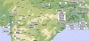
Map of the North and Central parts |
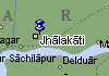 |
A map |
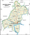 |
A map |
Photo Collection
Places
India
Jhalokati
On 19 June 1909, Sri Aurobindo gives a speech at Jalocati, Barisal District
Maps
Photos
 |
 |
 |
 |
Jhalokati, town and a municipal district, consists of 9 wards and 47 mahallas. The area of the town is 6.37 sq km. The town has a population of 45095; male 53.11%, female 46.89%; density of population is 7079 per sq km. Literacy rate among the town people is 67.5%. The town has two dakbungalows. Population of the District is 195,619; male 51.13%, female 48.87%; Muslim 79.43%, Hindu 20.53% and others 0.04%.
Administration Jhalokati thana was established in 1882 and was turned into an upazila in 1983. It consists of one municipality, 9 wards, 9 union parishads, 179 mouzas and 176 villages. 17 Muslims were killed in an encounter between the British army and the local Muslims in 1927.
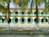
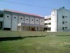
Remnants of the Ghoshal Rajbari, old Municipal Building, Nurullahpur Math. Religious institutions Mosque 470, temple 127. War of Liberation Memorial sculpture 1 (city park). Educational institutions: college 7, high school 54, madrasa 19, government primary school 113, non-government primary school 42. Noted institutions: Baharampur Government Primary School (1905), Municipal Model Government Primary School (1902), Bharukathi Government Primary School (1910). Cultural organisations Club 19, public library 2, theatre group 4, cinema hall 1, playground 24. Newspaper and periodical Daily Shatakantha (extinct). Health centres Hospital 1, family planning centre 11, satellite clinic 3.
Main occupations Agriculture 32.18%, agricultural labourer 14.89%, wage labourer 4.84%, commerce 16.12%, service 13.26%, industry 1.07%, transport 2.54%, construction 2.06% and others 13.04%. Land use Total cultivable land 9535.82 hectares; fallow land 102.39 hectares; single crop 48.80%, double crop 38.09% and treble crop 37.52%; cultivable land under irrigation 55%. Land control Among the peasants 20% are landless, 45% small, 28% intermediate and 7% are rich. Land value Market value of land of the first grade is approximately Tk. 5000 per 0.01 hectare. Main crops Paddy, potato, wheat, pulse, onion, brinjal, vegetables. Extinct or nearly extinct crops Jute, sesame, linseed and mustard seed. Main fruits Mango, banana, papaya and black berry. Fisheries, dairies, poultries Poultry 13, hatchery 1, fishery 120.
Roads: pucca 23 km, semi pucca 21 km and mud road 135 km. Traditional transport Palanquin, gaina boat, dingi boat. These means of transport are either extinct or nearly extinct. Manufactories Ice factory 3, flour mill 2, salt factory 5, rice mill 17, saw mill 14, bidi factory 1. Cottage industries Weaving 17, wood work 117, goldsmith 57, blacksmith 97, potteries 123, bamboo & cane work 202, pati (mat) making 52, tailoring 109, welding 16. Total number of hats and bazars are 27, fair 4, most noted of which are Baukati, Jhalokati, Gabkhan Hat. Main exports Paddy and salt.