 |
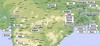
Map of the North and Central parts |
 |
A map |
 |
A map |
Photo Collection
Places
India
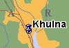
Khulna
14 June 1907. Trip to Khulna for a foundation of National School. 23 June 1909 — speech in Khulna.
Maps
Photos
 |
 |
 |
 |
 |
 |
 |
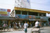 |
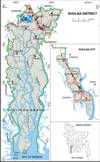
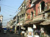
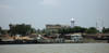
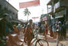
Khulna (town) is the third-largest city of Bangladesh, located on the bank of the rivers Rupsha and Bhairob. It is the capital of Khulna division and is a major industrial and commercial center. It has a seaport named Mongla on its outskirts. Town consists of 38 wards and 183 mahallas. The area of the town is 20.60 sq km. It has a population of 1,227,239; male 52.79%, female 47.21%. The literacy rate among the town people is 59.1%.
Administration Khulna district was established on 1882. It consists of 9 upazilas and 5 thanas, 71 union parishads, 2 municipalities, 47 wards, 188 mahallas, 747 mouzas and 1106 villages. Population 2334285; male 51.87%, female 48.13%; Muslim 73.49%, Hindu 25.74%, Christian 0.67%, Buddhist 0.04%, and Others 0.06%.
Pir Khan Jahan Ali came to preach Islam in this district in the early 17th century. At the 17th December 1971 (when the Pakistani Army surrendered) Khulna got her independence.
Marks of War of Liberation Sculpture 1 (Bir Bangali), Monument 5, Mass grave 3. Religious institutions Mosque 1500, Tomb 4, Temple 646, Church 22, Place of pilgrimage 3, Monastery 1.
Educational institutions: university 1, university college 1, medical college 1, Bangladesh Institute of Technology 1, teacher's training college 1, regional public administration training institute 1, polytechnic institute 1, vocational institute 1, homeopathic college 1, social welfare training centre 1, madrasa 205, government college 5, non-government college 42, government. secondary school 9, non-government secondary school 248, lower secondary school 107, government primary school 625, non-government primary school 79, community primary school 34, satellite primary school 63, NGO operated school 199, primary teacher's institution 1. Cultural organisations Club 345, public library 5, museum 1 (Khulna Divisional Archaeological Museum), drama stage 5, cinema hall 21, theatre group 100, magic organisation 3, literary society 15, cultural organisation 20. Main occupations Agriculture 25.11%, fishing 1.66%, agricultural labourer 11.3%, wage labourer 7.15%, industry 16.38%, transport 4.09%, constructions 1.53%, service 18.93%, others 12.22%.
Manufactories Paper mill, hard board mill, textile mill, match factory, shipyard, steel mill, cable mill, rice mill, flour mill, ice factory, press mill, saw mill etc. Handloom, bamboo work, goldsmith, potteries, carpenter, tailoring.
Main crops Paddy, jute, sesame, betel nut, and vegetable. Extinct and nearly extinct crops Sesame. Main fruits Jackfruit, mango, banana. Fisheries, dairies, and poultries Chingri Gher 3,409, dairy 498, poultry 447, hatchery 348. Main exports: Paddy, rice, jute, sesame, betel nut, gur, mango, jackfruit, prawn.
The city is 375 km southwest of Bangladesh's capital Dhaka, to which it is connected by air, road, train and sea transportation. Railway 36 km, pucca road 400 km, semi pucca 350 km, mud roads 3575 km; waterways 470 nautical mile. Traditional transport Palanquin (extinct), horse carriage and bullock cart (nearly extinct), and boats.
Health centres Medical college hospital 1, district sadar hospital 1, upazila health complex 9, TB hospital 1, infectious disease hospital 1, christian missionary hospital 1, salvation army (NGO) hospital 1, chest disease niramoy centre 1, railway hospital at kopilmuni 1, jail hospital 1, police hospital 1.