 |
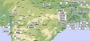
Map of the North and Central parts |
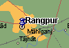 |
A map |
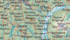 |
A map |
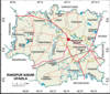 |
A map |
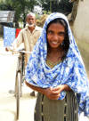
Photo Collection
Places
India
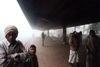
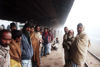
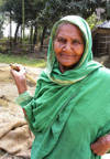
Rangpur
October 1871. Dr. Ghose was given a new post as assistant surgeon in charge of the civil station of Rangpur. He and his family arrived in the remote northern town around the end of October.
In the summer of 1872 in Rangpur was outbreak of malaria followed by a cholera, so Dr. Ghose decided to send his pregnant wife to the comparatively healthy environment of Calcutta. Shortly after Sri Aurobindo was born, he and his mother returned to Rangpur. It is there first five years of Sri Aurobindo’s childhood went by.
In February 1873 Dr. Ghose was named the district’s (population was about 2,000,000) civil surgeon.
Occasionally the family used to go to Deoghar to stay with Swarnalata’s father, Rajnarayan Bose. Aurobindo did not know Bengali for these first five years. There were a butler and a nurse in the house, and he used to talk with them in broken English and similar Hindusthani. An incident in childhood: Jogendra, Sri Aurobindo’s eldest maternal uncle, once held up a mirror to Aurobindo and said: “See, there is a monkey.” After some time Aurobindo, the child, took the mirror to Jogendra, held it up to him and said: “Great uncle, great monkey!”
Maps
Photos
 |
 |
 |
 |
 |
 |
 |
 |
 |
 |
 |
 |
 |
 |
 |
 |
 |
 |
 |
 |
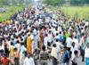
Rangpur, town, northwestern Bangladesh, on the Ghaghat River. It consists of 15 wards and 109 mahallas. It has an area of 42.57sq km. Population (1981) 153,174. Literacy rate among the town people is 54.6%. Rangpur town was turned into a municipality in 1869 and now it is a headquarters of the district that has the same name. District is a Rajshahi division of Bangladesh. Rangpur district consists of 3 municipalities (Rangpur Sadar, Badarganj, and Kaunia), 15 wards, 12 union parishads, 207 mouzas and 311 villages. Population of municipality (1991) 2,271,000, (1996) 2,659,816, (2006) 2,809,844.
Rangpur ("Abode of Bliss") is said to be the site where Raja Bhagadatta, who took part in the war recorded in the Mahabharata (c. 400 BC-AD 200), had a country residence. Mansingh, a commander of the Mughal emperor, Akbar, conquered Rangpur in 1575, but it be completely integrated with the Mughal Empire only by 1686. Names of places like Mughalbasa (literal meaning being a locality of the Mughals), and Mughalhat (literal meaning a “local market” organized by the Mughals) bear testimony to the Mughal association and past of Rangpur and its hinterland. Later on, Rangpur passed under the control of “Sarker” of Ghoraghat. During the period of the East India Company, Fakir-Sannyasi Rebellion took place.
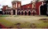
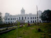
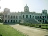
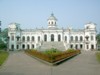
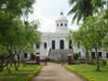
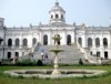
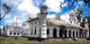
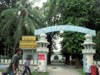
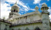
Archaeological heritage and relics Tajhat Rajbari, Keramatia Mosque, Dimlaraj Kali Mandir, Sree Sree Karunamaye Kali Mandir, Rangpur Museum, Rangpur Town Hall, Rangpur Public Library, Pareshnath Mandir at Mahiganj, tomb of Maulana Keramat Ali Jainpuri, tomb of Shah Jalal Bokheri at Mahiganj, carmichael college Building, home stead of roquiah sakhawat hossain at Pairabandh, Zila Parishad Building.
Religious institutions Mosque 380, temple 35, church 2, tomb 5 and sacred place 1. Literacy and educational institutions Average literacy 37.4%; male 43.9% and female 30.1%. Educational institutions: college 17, medical college 1, technical college 1, teacher's training college 1, cadet college 1, PTI 1, high school 58, junior high school 5, madrasa 72, government primary school 149, non-government primary school 73, kindergarten 18, satellite school 18 and NGO operated school 120 and community school 15. Noted Educational institutions: Rangpur Zila School (1832), Carmichael University College (1916), Rangpur Girl's High School (1876). Cultural organisations Club 181, public library 2, cinema hall 7, theatre group 6, theatre stage 1, museum 1 and literary society 3.
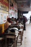
The surrounding area is composed of a vast alluvial plain. Most of the area is under continuous cultivation (tobacco, rice, jute, and oilseeds). An extensive rail network distributes the products of Rangpur's jute, rice, and sugar mills and cotton- and silk-weaving cottage industries. Town is an industrial centre noted for the manufacture of dhurries (cotton carpets), bidis (cigarettes), and cigars.
Main occupations Agriculture 24.71%, agricultural labourer 19.39%, wage labourer 4.81%, commerce 17.91%, service 14.94%, transport 5.93% and others 12.31%. Main crops Paddy, jute, wheat, potato, onion, garlic, ginger, chilli, sugarcane and tobacco. Main fruits Mango, jackfruit, black berry, papaya and banana. Fisheries, poultries Poultry 40, fishery 20 and hatchery 9. Communication facilities Roads: pucca 191 km, semi pucca 15 km and mud road 580 km. Manufactories Rangpur Foundry Limited, RK Fan, RV Oil Mill, Rahatin Industries. Other manufactories include rice and flour mill, saw mill, ice factory, printing press, lathe machine and welding. Cottage industries Bamboo work 180, goldsmith 40, blacksmith 70, potteries 125, wood work 120, tailoring 270 and bidi 30. Main exports Paddy, wheat, sugarcane, ginger, tobacco and vegetables. Health centres Medical college hospital 1, zila sadar hospital 1, T B hospital 1, eye hospital 1, union health and family welfare centre 10, charitable dispensary 1, municipal medical centre 1, maternity and child welfare centre 1. [Abdus Sattar]