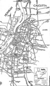
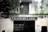
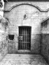
Alipore. South-West suburb of Calcutta. From 02 May 1908 till 06 May 1909 Sri Aurobindo was prisoned at Alipor jail at the outskirts of the Calcutta.
Beadon Square (now Rabindra Kanan): 14 December 1907 , the first public speech of Sri Aurobindo; 13 June 1909 again speech at Beadon Square.
Creek Row: Bande Mataram office
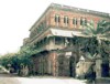
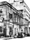
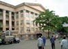
6 College Square: the house of Kristo Kumar Mitter, where Sri Aurobindo lived from May 1909 till his leaving of Calcutta in February 1910.
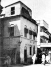
48 Gray Street (now Shree Aurobindo Sarani): is the place to which Sri Aurobindo moved on the evening of 28 April 1908. Here he planned not only live but also to publish the newspaper “Navashakti” - planes overturned by his arrest on 2 May.
Kumartuli. District at Calcutta. Here Sri Aurobindo gave a speech at 9 July of 1909.
237, Lower Circular Road: one of the two possible addresses where Sri Aurobindo was born
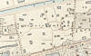
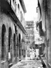
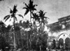
Mannictolla (Munictollah): District, suburb of Calcutta: place where Muraripukar garden (Muraripooker Road, Manicktollah Garden) house was situated where Barin and other prepared terroristic acts against British rule (Bomb Trial)
23, Scott's Lane (Muchipara District): where Sri Aurobindo with his wife and her sister lived from February to April 1908
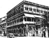
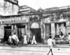
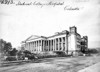
4 Shyam Pukur Street: Calcutta office of the “Karmayogin” and “Dharma”
4, Theatre Road (now Shakespeare Sarani) one of possible addresses where Sri Aurobindo was born
48 Gray Street, Calcutta (since demolished) is the place to which Sri Aurobindo moved on the evening of 28 April 1908. Here he planned not only live but also to publish the newspaper “Navashakti” - planes overturned by his arrest on 2 May.
4 Shyam Pukur Lane is the address given in contemporary documents for the office of the Karmayogin and Dharma newspapers. The photograph is identified as 4 Shyam Pukur Street. It is to be determined whether the house shown is the correct one — for the Shyam Bazar section of Calcutta contains both a Shyam Pukur Lane and a Shyam Pukur Street. (1-st issue of the “Karmayogin" - 19 June 1909, of the “Dharma” - 23 August 1909)
The house of Kristo Kumar Mitter, where Sri Aurobindo lived from May 1909 till his leaving of Calcutta in February 1910.
Kristo Kumar Mitter was Sri Aurobindo’s maternal uncle, one of nine nationalists who were deported from Bengal in December 1908. House, where lived his family, also served as the office and plant of the Bengali journal “Sanjivani”, edited by Krishna Kumar. From police report: “Aurobindo spends most of his day in study of religious books and in writing. He is said to be accessible to almost anyone, known or unknown, who goes to call on him. His principal associates, whom he visits and is visited by are Babu Ramananda Chatterji, Gispati Kabyatirtha, Lalit Mohan Das, Prasanna Kumar Bose, Jitendra Nath Banerji, Gyan Chunder Roy; C.R. Das, Barrister-at-law; B.K. Das, Barrister-at-law; B.C. Chatterji, Barrister-at-law; S.N. Halder, Barrister-at-law; and P. Mitter.”
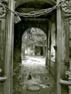
The Muraripukar Garden was a piece of property located in "an obscure quarter of the suburb" of Maniktolla. Since the death of their father K.D. Ghose, it had been owned by Sri Aurobindo and his brothers. 32 Muraripukur Road consisted of a "rather large piece of ground", one hectare in extend, at the centre of which was a small "garden house". The place "had been allowed to run wild and a good deal of jungle had sprung up" (judge of Bomb Trial). In 1906 Sri Aurobindo had tried to sell it, but not find no one interested in a property "infested by monkeys".
Muraripukar Garden house was a place of meeting of young nationalists which prepared terroristic acts against British rule. Sri Aurobindo knew about this but did not participate in this action.
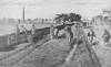
2 May. 5 o’clock. Sri Aurobindo arrested by burst in polices. Chained up and tight. Private letters were confiscated. Was taken to the police station. Accused of participation at terroristic organisation. After some hours was moved to Alipor jail at the outskirts of the Calcutta.
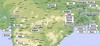
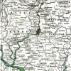
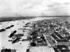
Calcutta, or Kalikata on Bengali, city, since 1947 capital of West Bengal state, and former capital (1772-1912) of British India. The nation's largest metropolitan area and a major port, Calcutta is located on the eastern bank of the Hooghly River, an arm of the Ganges, about 154 km upstream from its mouth at the head of the Bay of Bengal. The port city developed as a point of trans-shipment from water to land and from river to sea. The city proper has an area of 104 square kilometres; the metropolitan area, 1,380 square km. Population (1981) city, 3,305,006; metropolitan area, 11,100,000. A city of commerce, transport, and manufacture, Calcutta is the dominant urban centre of eastern India.
Climate
Although Calcutta is favourably located for trade, its low, swampy, hot, and humid riverbank location is not ideal for human habitation. In reality the humid and uncomfortable climate, putrefying salt marshes (eastward from the river) and the hovels that grew haphazardly around the city created unhygienic conditions that were a constant source of misery and disease. Similar topography on the western bank has confined the metropolitan area to a strip 5-8 km wide on either bank, although reclamation projects have expanded the limits of usable land to the east, south, and west of the central city. The city has numerous slum areas, occupied by about one-third of the inhabitants. The city's climate is subtropical. The summer season is very uncomfortable here, which is followed by cozy monsoon. During winter the temperature remains around 27° C. This gives relief but also one has to face troublesome roads full of mud and water. The months October and November are pleasant.
City name
The city's name is an Anglicized version of Kalikata. There are some versions of derivation of this name:
(1) from Kalikutir (The temple of Kali), the temple of kalighat;
(2) from the Bengali word Kalikshetra, meaning "Ground of Kali";
(3) from the location of its original settlement on the bank of a canal (khal);
(4) from Bengali words for lime (kali) and burnt shell (kata);
(5) from the Bengali term kilkila (meaning, "flat area"), which is mentioned in the old literature.
City history
On the early pre-history of the coastal portion of the Gangetic delta we can judge through some archaeological findings: tusk of Elephas noadicus and fossilised pollen of cultivable grass (probably paddy) ascribable to c 5000 BC, anthropogenic neolithic material of about 2.5 thousand years. These findings convincingly refute the popular belief that the first settlements are of 7th century AD formation.
Sutanati which is the place on the east bank of the Hooghly, was made the headquarters of the East India Company in 1690 by Job Charnock .The river side was already the centre of the trading communities of the European countries. East India Company established themselves at the Sutanati area which they purchased with the Help of Armenia and completed their first fort in Sutanati area named Fort William in 1699. Few years later East India company undertook two more villages besides Sutanati and made Calcutta. Job Charnock was the governor of Calcutta and he married an Indian woman whom he rescued from being sati. Trading success encouraged East India Company for further ambitious plans for development. In this process the delegation of East India Company visited the Mogul court in Delhi and negotiated trading rights, along with several villages and towns on both banks of the Hooghly, to create a territory which was around fifteen kilometres long. The company made a ditch around the place to save themselves from the possible Maratha attack.
In 1717 the Mughal emperor Farrukh-siyar granted the East India Company freedom of trade in return for a yearly payment of 3,000 rupees; this arrangement gave a great impetus to the growth of Calcutta. A large number of Indian merchants flocked to the city. The servants of the company, under the company's flag, carried on a duty-free private trade. When the Marathas from the southwest began incursions against the Mughals in the western districts of Bengal in 1742, the English obtained permission from 'Ali Vardi Khan, the nawab (ruler) of Bengal, to dig an entrenchment in the northern and eastern part of the town to form a moat on the land side. This came to be known as the Maratha Ditch. Although it was not completed to the southern end of the settlement, it marked the city's eastern boundary. In 1756 the Nawab's successor, Siraj-ud-Dawlah, captured the fort and sacked the town. Calcutta was recaptured in January 1757 by Robert Clive, one of the founders of British power in India, and by the British admiral Charles Watson. The Nawab was defeated shortly afterward at Plassey (June 1757), after which British rule in Bengal was assured. Gobindapore was cleared of its forests, and the new Fort William was built on its present site, overlooking the Hooghly at Calcutta, where it became the symbol of British military ascendancy.
Calcutta did not become the capital of British India until 1772, when the first governor-general, Warren Hastings, transferred all important offices to the city from Murshidabad, the provincial Mughal capital. In 1773 Bombay and Madras became subordinate to the government at Fort William. A supreme court administering English law began to exercise original jurisdiction over the city as far as the Maratha Ditch (now Acharya Prafulla Chandra and Jagadish Chandra Bose roads).
In 1706 the population of Calcutta had been about 10,000 to 12,000. It increased to nearly 120,000 by 1752 and to 180,000 by 1821. The White (British) Town was built on ground that had been raised and drained. There were so many palaces in the British sector of the city that it was named the "city of palaces." Outside the British town were built the mansions of the newly rich, as well as clusters of huts. The names of different quarters of the city–such as Kumartuli (the potters' district) and Sankaripara (the conch-shell workers' district) – still indicate the various occupational castes of the people who became residents of the growing metropolis. Two distinct areas – one British, one Indian – came to coexist in Calcutta.
Calcutta at this time was described as a pestilential town. There were few good roads. In 1814 a Lottery Committee was constituted to finance public improvement by means of lotteries, and between 1814 and 1836 it took some effective measures to improve conditions. The corporation was established in 1841. Cyclones in 1864, 1867, and 1870, however, devastated the poorer, low-lying areas.
By successive stages, as British power extended over the subcontinent, the whole of northern India became a hinterland for the port of Calcutta. The abolition of inland customs duties in 1835 created an open market, and the construction of railways (beginning in 1854) further quickened the development of business and industry. It was at this time that the Grand Trunk Road from Calcutta to Peshawar (now in Pakistan) was completed. British mercantile, banking, and insurance interests flourished. The Indian sector of Calcutta also became a busy hub of commerce and was thronged with people from all parts of India and many other parts of Asia.
Memorials, culture, arts, education
Calcutta is a major educational and cultural centre, catering to a cosmopolitan population speaking Bengali, English, Hindi, and Urdu. Higher education is offered by the universities of Calcutta, Jadavpur, and Rabindra Bharati. The Indian Museum is the oldest in India. Other museums offer collections of archaeological and historical artifacts and folk and fine arts. Valuable library collections are housed in the National Library.
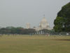
One of the city's chief recreational areas is the Maidan (plain, or park), occupying about 1,300 acres (500 hectares) along the river; major sporting events are held there. Western and Eastern influences mingle in Calcutta's architecture: Victoria Memorial, one of the city's finest buildings, represents a mixture of classical Western and Mughal (Mogul) styles.
Most of the attractions of Calcutta are around the Maidan which is one of the few open spaces in the city. The Maidan was created in 1758 by clearing the jungle around the new Fort William. This was to allow the guns to fire freely. Strangely enough not a single shot has been fired from the fort. The treeless character of the Maidan changed almost a century later when trees were planted and avenues constructed. Access to this park was limited during the British rule. Today it is a free public park and the Maidan is the pulse of Calcutta's throbbing life. Access to the Fort William is still restricted.
To the east of the Victoria Memorial Hall is a triangular plot of land which forms the cultural complex of the city. It is anchored by the a modern auditorium called the Rabindra Sadan and a cinema complex called the Nandan. A smaller theater called the Sisir Mancha, the Pashchim Bangla Academy, the Academy of Fine Arts and the Calcutta Information Centre complete the setup. Slightly ahead towards Shakespeare Sarani is the St Paul's Cathedral, which was built in 1837. Next to it is the Birla Planetarium. It is modeled after the Buddhist stupa of Sanchi. On Chowringhee road near the Rabindra Sadan Metro station is the Nehru Children's Museum which has a clay doll exhibition based on the story of Ramayana and the Mahabharata.
Economics
Calcutta is the world's largest processor of jute; also important are food processing, hosiery and footwear production, the manufacture of textiles, and the making of iron and steel goods. The coal mines, tea gardens, and industrial concerns of West Bengal and neighbouring states are managed and financed from Calcutta. Chief exports through the city's port are crude steel, pig iron, coal, machinery, gunnies (jute sacking), sugar, and tea. Calcutta is eastern India's financial headquarters, with many foreign banks, several chambers of commerce, and a stock exchange.
Transport
Calcutta's streets are mostly narrow and in poor condition. Construction of India's first subway system was begun in Calcutta in 1973; a section in the central area opened in 1986. National highways and railways connect Calcutta to other cities; Sealdah and Howrah stations are the terminals of several railway lines; and air service is provided by the Dum Dum International Airport.
Modern Calcutta was inaugurated by the introduction of the railway communications. The idea of connecting Calcutta to the other parts of the sub-continent by railways started with the proposal of the Calcutta-Ranigunge coalfields route (1850). The construction commenced in 1851 and Hooghly (Sept.1854), Barddhaman (Dec. 1854) and Ranigunge (Feb.1855) were promptly connected. Between the opening of the Ranigunge - Asansol (1863) and the Dankuni - Sealdah (1932) lines, a network of criscrossing circuits enhanced Calcutta's rail-communication through the Howrah and Sealdah stations.